Anti-interference, low power consumption, high precision multi-mode satellite positioning technology — bringing you a brand new precise experience
The GPS02-UBX is a quad-mode satellite navigation GPS module with high anti-interference capabilities and low power consumption. The module supports multiple satellite frequencies and can be connected to either active or passive antennas (users can choose the appropriate antenna based on the operating mode). It provides precise signal acquisition and tracking, real-time output of speed and location information, and enables BeiDou positioning functionality.
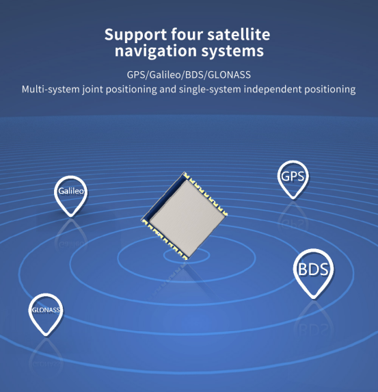
Supports BDS B1I/B1C, GPS L1 C/A, GLONASS L1OF, and Galileo E1 frequencies
Supports multiple satellite navigation bands, ensuring high-precision positioning services globally, and enhancing the stability and reliability of positioning
BDS (BeiDou Navigation Satellite System): BDS not only provides standard positioning and navigation services but also offers messaging communication and search-and-rescue functions. Its positioning accuracy is typically within 2.5 meters.
GPS (Global Positioning System): GPS is characterized by its global coverage and high-precision positioning, with an accuracy typically within 5 meters. It is widely used across various fields, supporting navigation, positioning, time synchronization, and speed measurement functions. GPS is applied in transportation, logistics, agriculture, geographic information systems, and many other industries.
GLONASS (Global Navigation Satellite System): Similar to GPS, GLONASS offers global positioning and navigation services, with an accuracy typically between 5-10 meters. A significant feature of GLONASS is its superior performance in high-latitude areas. It also excels in anti-interference capabilities, maintaining stable signal transmission even in complex environments.
Galileo (Satellite Navigation System): Provides high-precision global positioning services, with accuracy typically within 1 meter. It excels in various application scenarios, particularly in high-precision mapping, autonomous driving, and drone navigation.
QZSS (Quasi-Zenith Satellite System): QZSS is a regional satellite navigation system developed by Japan, providing stable enhancement services in Japan and its surrounding areas.
SBAS (Satellite-Based Augmentation System): Offers enhanced stability and accuracy, suitable for aviation and other high-safety requirement sectors.
Supports single-mode, dual-mode, and multi-mode operation
Supports single-mode, dual-mode, and multi-mode operation for BDS, GPS, GLONASS, and Galileo, enabling the system to provide flexible positioning solutions under different environments and requirements. Users can switch between different working modes through simple commands based on the actual application scenario to achieve optimal positioning performance.
Supports A-GNSS (Assisted GNSS) for enhanced positioning
A-GNSS (Assisted GNSS) combines information from satellites and ground networks to provide faster and more accurate positioning services, ensuring reliable location services under various conditions.
Characteristics of high-precision GPS satellite positioning navigation and Beidou module
High sensitivity
The module's cold start capture sensitivity can reach -147 dBm, and tracking sensitivity can reach -163 dBm, ensuring rapid acquisition and tracking of satellite signals even in low signal environments.
Strong anti-interference, low power consumption
It features strong anti-interference capabilities and low power consumption, ensuring stable operation in complex environments while extending the device's battery life.
High Precision: The module utilizes satellite signals from GPS and BeiDou navigation systems to provide a highly accurate time source. These satellites precisely measure location and time.
Multi-satellite low drift technology, by receiving signals from multiple satellites and fusing data, provides high-precision and stable positioning services, reducing drift caused by environmental changes.
Uses the new generation UBLOX IC
The GPS uses UBLOX's latest generation IC from the M10 series, providing high precision and stability in positioning services.
Multi-System Compatibility: The system defaults to a tri-mode working mode utilizing BDS, GPS, and Galileo. In the majority of cases, users can benefit from the collaborative advantages of these three major navigation systems, achieving high precision and high reliability in positioning.
Multi-Satellite Reception: The module is capable of receiving signals from multiple satellites simultaneously, including both GPS and BeiDou satellites. By receiving signals from multiple satellites, it can provide more accurate and stable time synchronization services.
Precise Time Synchronization: The module can provide accurate time information to user devices, achieving precise time synchronization.
High Reliability: The GPS and BeiDou navigation systems are highly reliable, having been proven stable over long periods of operation and verification.
Flexible Deployment and Integration: The high-precision GPS BeiDou module can be flexibly deployed and integrated into various application scenarios.
 +86-755-23080616
 sales@nicerf.com
Website: https://www.nicerf.com/
Address: 309-314, 3/F, Bldg A, Hongdu business building, Zone 43, Baoan Dist, Shenzhen, China


 English


