How to choose GPS module?
The GPS module integrates a baseband chip and peripheral circuits, and can communicate with the Global Navigation Satellite System (GNSS) for positioning and navigation without consuming traffic. All devices equipped with GPS modules can communicate with GPS-synchronized satellites free of charge at any time and in any region. There are many GPS modules on the market, so how do we choose?
Method of selecting GPS Module
1. Which satellite navigation systems are supported
Global Navigation Satellite System (GNSS) refers to all satellite navigation systems, including global, regional and augmented, such as the United States' Global Positioning System (GPS), the European Union's Galileo Satellite Navigation System (GALILEO), and China's Beidou satellites. Navigation System (BDS), Russia's GLONASS Satellite Navigation System (GLONASS), and related augmentation systems. For foreign users, it generally depends on whether the GPS module supports GPS/GLONASS/GALILEO.
| Global System | Zone System | Augmentation System (SBAS) |
| United States (GPS) | Japan (QZSS) | United States (WASS) |
| European Union (GALILEO) | India (IRNSS) | Japan (MSAS) |
| China (BDS) | European Union (EGNOS) | |
| Russia (GLONASS) | India (GAGAN) | |
| Nigeria (NIG-COMSAT-1) |
2. Good receiving sensitivity
Receive sensitivity is the minimum signal received power that the receiver can accurately take out the effective signal. The good receiving sensitivity of the GPS module enables wireless products to have a stronger ability to capture weak signals. In this way, along with the improvement of transmission spacing, the received signal becomes weaker, and high-sensitivity wireless products can still receive data, maintain a stable connection, and greatly increase the transmission distance.
3. Faster and faster positioning time
The positioning time refers to how long it takes for the GPS device to start to determine its specific location, usually in seconds. When this time is reached, the GPS device will send a signal to the GPS positioning satellite and begin to determine its specific location. It also includes the positioning time for the first operation, cold start, and hot (warm) start. Whether it is car navigation or the navigation map in the mobile phone, it is all based on the GPS module. The less time it takes to locate, the easier it is for engineers to confirm the data test.
4. Position accuracy of GPS module
Position accuracy refers to the degree to which the coordinate value obtained by the spatial point corresponds to its actual coordinate value. If the positioning accuracy is not functional and practical, even the luxurious GPS design and layout will make people unhappy. However, different navigation environments must first consider the application scenario, and then consider other factors.
The positioning accuracy can be investigated under static and dynamic conditions, and the actual effect of dynamic positioning is better than that of static positioning. The nominal positioning technical parameters of the GPS module refer to the measurement under the condition of fully open sky and high-quality satellite signals. Therefore, it is difficult to achieve the nominal positioning time and positioning accuracy in routine testing.
5. Power consumption of GPS module
Power consumption is the loss of power, which refers to the difference between the input power and output power of machines, devices, etc.. With the rapid growth of computer technology and microelectronics technology, the application scenarios of embedded systems are becoming more and more extensive. Environmental protection and energy saving is an international trend. For example, many chips in computers used to be powered by 5V, nowadays they are powered by 3.3V and 1.8V, and the definition of green system is clearly put forward. Many manufacturers attach great importance to the low power consumption of GPS modules. The low-power design of circuits and systems is always an important consideration for electronic engineering professionals.
6. Signal-to-noise ratio of GPS Module
The signal-to-noise ratio (SNR) is simply the signal strength of the satellite and is a measure of the signal information content of signal-to-noise. In the same test environment, the larger the detected satellite signal-to-noise ratio, the better the GPS module performance.
How to choose NiceRF GPS module
| Product model | GPS02-TD | GPS02-UBX | GPS01-TD | GPS01 |
| Product Image |  |  | ||
| Support satellite navigation system | GPS/ Galileo/BDS/GLONASS | GPS/ Galileo/BDS/GLONASS (Choose three of four, BDS and GLONASS cannot be used at the same time.) | GPS/ Galileo/BDS/GLONASS | GPS/BDS/GLONASS |
| Auxiliary Satellite Navigation System | Support SBAS and QZSS | Support SBAS and QZSS | Support SBAS and QZSS | |
| Position | Support A-GNSS assisted positioning | Support A-GNSS assisted positioning | Support A-GNSS assisted positioning | Support A-GNSS assisted positioning |
| Operating mode | 1. Support GPS, Galileo, BDS, GLONASS single system work; 2. Support dual system work; 3. Support GPS/BDS/GLNOASS, GPS/Galileo/BDS three systems; 4. Support GPS/Galileo/BDS/GLNOASS four system work | 1. Support GPS, Galileo, BDS, GLONASS single system work; 2. Support dual system work; 3. Support GPS/Galileo/GLONASS, GPS/Galileo/BDS three systems; | 1. Support GPS, Galileo, BDS, GLONASS single system work; 2. Support dual system work; 3. Support GPS/GLNOASS/BDS, GPS/Galileo/BDS three systems; 4. Support GPS/Galileo/BDS/GLNOASS four system work | 1. Support GPS, BDS, GLONASS single system work; 2. Support GPS/BDS, BDS/GLNOASS, GPS/GLONASS dual system work |
| Sensitivity | Capture: -147dBm Tracking: -163dBm | Capture: -148dBm Tracking: -166dBm | Capture: -147dBm Tracking: -163dBm | Capture: -147dBm Tracking: -163dBm |
| Data update rate | Single system: 1~20Hz Dual system: 1~10Hz Three systems: 1~10Hz Four systems: 1~10Hz | Single system: 1~18Hz Dual system: 1~10Hz Three systems: 1~10Hz | Single system: 1~20Hz Dual system: 1~10Hz Three systems: 1~10Hz Four systems: 1~10Hz | Single system: 1Hz Dual system: 1Hz |
| Operating voltage range | VCC:3~3.5V V_BCKP:2.5~3.5V | VCC:2.7~3.6V V_BCKP:2.5~3.5V | VCC:3~3.5V V_BCKP:2.5~3.5V | VCC:3~3.5V V_BCKP:2.5~3.5V |
| Receive current | <35mA | <25mA | <35mA | <30mA |
| Sleep current | <25uA | <35uA | <25uA | <20uA |
| Time to first fix TTFF | cold start <28s, hot start: 1s, recapture: 1s | |||
| Positioning accuracy | level <3m, elevation <4.5m @Open land | |||
| Speed measurement accuracy | <0.1m/s | |||
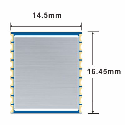
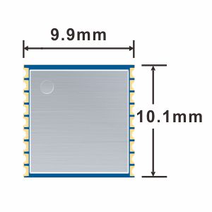
| Size (L*W*T) | 16.45*14.5*2.3 mm | 16.45*14.5*2.3 mm | 10.1*9.9*2 mm | 10.1*9.9*2 mm |
 +86-755-23080616
 sales@nicerf.com
Website: https://www.nicerf.com/
Address: 309-314, 3/F, Bldg A, Hongdu business building, Zone 43, Baoan Dist, Shenzhen, China


